Search

Children who live in the outer suburbs of Australia’s four biggest cities are twice as likely to have asthma as those living in inner city areas, according to a new study based on health data captured in the last Australian Census.
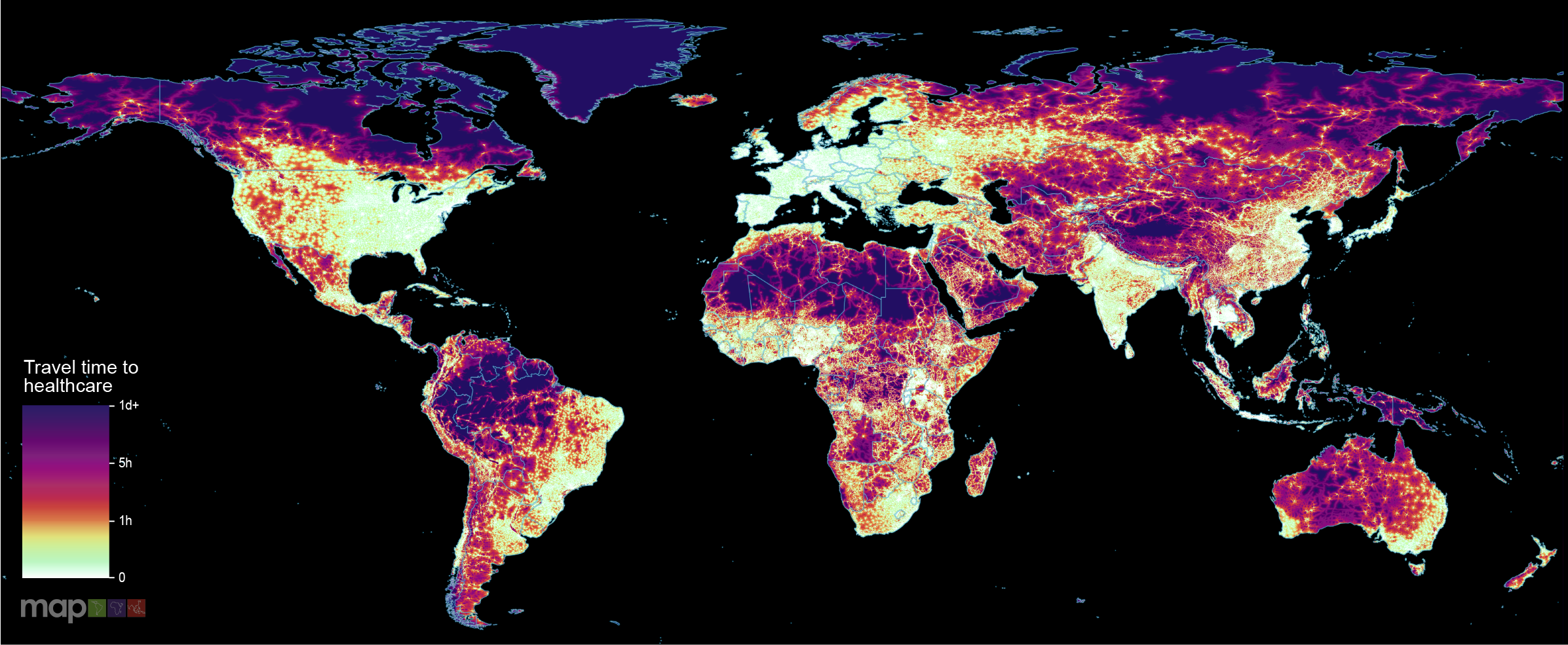
New research which maps the entire global population’s travel time to their nearest healthcare facility has revealed major inequalities in access to healthcare depending on whether people have access to motorised transport or not.
Tuberculosis (TB) remains a major public health challenge in Ethiopia, despite being a preventable disease. TB preventive treatment (TPT) is a critical intervention to prevent the progression from latent TB infection to active disease, particularly among household contacts of TB patients and people living with HIV due to weakened immunity. However, the initiation and completion rates of TPT at subnational and local levels have not been thoroughly investigated. This study aims to map facility-based TPT initiation and completion rates among household contacts of TB across Ethiopia.
In the austral summer of 2021-2022, Australia experienced an unprecedented Japanese encephalitis virus (JEV) outbreak, with detections over 3000 km south of previous occurrences. Given the limited knowledge of JEV transmission ecology in Australia, we developed geospatial models of transmission risk to support the public health response. We created time-varying habitat suitability models for suspected mosquito vectors and ardeid hosts using month-scaled occurrence and covariate data from 2000-2023.
Strongyloidiasis, caused by the soil-transmitted helminth Strongyloides stercoralis, remains a neglected public health issue in Australia, particularly among remote Aboriginal and Torres Strait Islander communities. This study aimed to map the spatial distribution of strongyloidiasis and investigate associated socioecological factors to identify high-risk areas and guide targeted interventions in Australia.
Malaria is a focal disease and more localized in low endemic areas. The disease is increasingly becoming a concern in urban areas in most sub-Saharan African countries. The growing threats of Anopheles stephensi and insecticide resistance magnify this concern and hamper elimination efforts. It is, therefore, imperative to identify areas, within urban settings, of high-risk of malaria to help better target interventions.
Bacillus Calmette-Guérin (BCG) protects children from severe tuberculosis and remains the only licensed vaccine for tuberculosis. Subnational estimates of BCG coverage are essential for identifying underserved populations across Africa. This study aimed to map BCG vaccination coverage in Africa from 1990 to 2022.
Malaria imposes a significant global health burden and remains a major cause of child mortality in sub-Saharan Africa. In many countries, malaria transmission varies seasonally. The use of seasonally-deployed interventions is expanding, and the effectiveness of these control measures hinges on quantitative and geographically-specific characterisations of malaria seasonality.
Since its inception in 2005, the US President's Malaria Initiative (PMI) has played a major role in the reductions in malaria morbidity and mortality observed across Africa. With the status of PMI funding and operations currently uncertain, we aimed to quantify the impact that a fully functioning PMI would have on malaria cases and deaths in Africa during 2025.
Arboviruses transmitted mainly by Aedes (Stegomyia) aegypti and Ae. albopictus, including dengue, chikungunya, and Zika viruses, and yellow fever virus in urban settings, pose an escalating global threat. Existing risk maps, often hampered by surveillance biases, may underestimate or misrepresent the true distribution of these diseases and do not incorporate epidemiological similarities despite shared vector species.