Search

News & Events
Census data reveals stark gap in asthma risk for inner and outer city kidsChildren who live in the outer suburbs of Australia’s four biggest cities are twice as likely to have asthma as those living in inner city areas, according to a new study based on health data captured in the last Australian Census.
News & Events
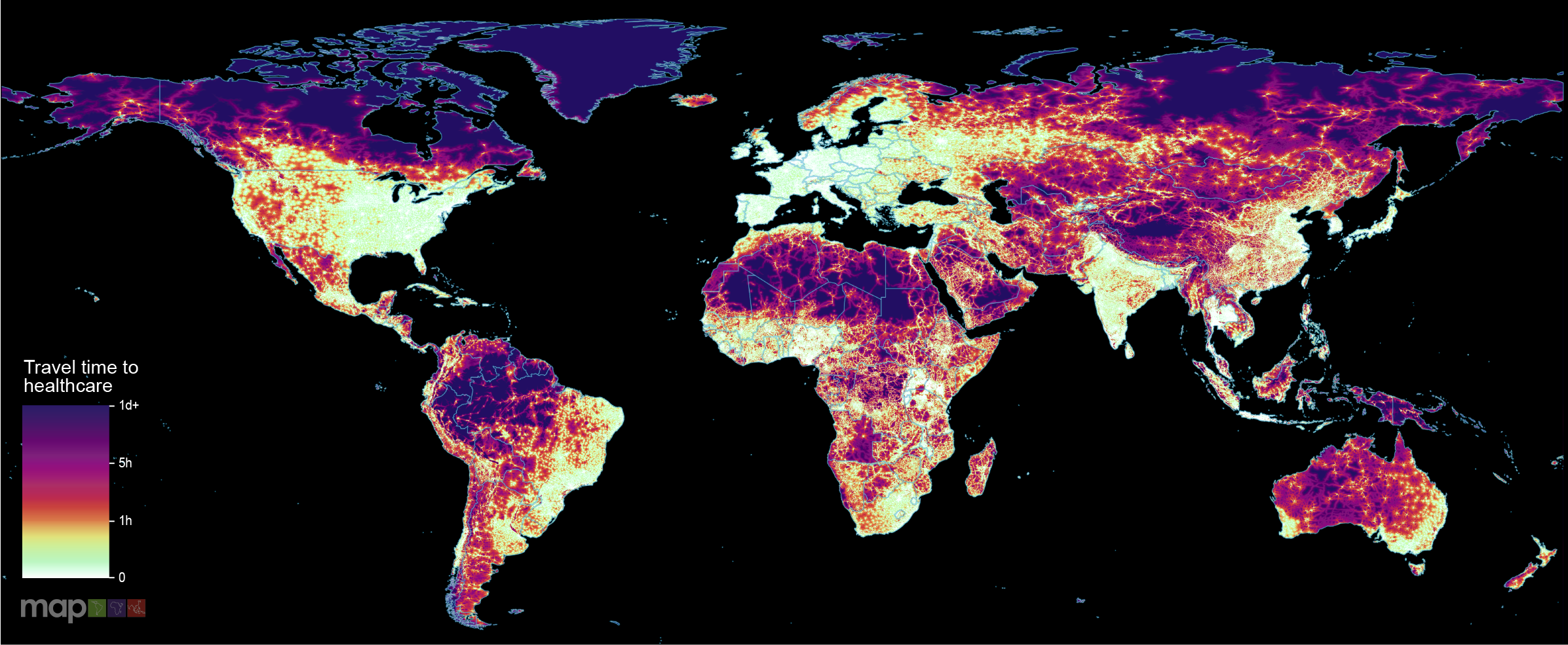
World-first maps reveal how long it takes to reach healthcare from anywhere in the globeNew research which maps the entire global population’s travel time to their nearest healthcare facility has revealed major inequalities in access to healthcare depending on whether people have access to motorised transport or not.
Research
Neighborhood Places for Preschool Children's Physical Activity: A Mixed-Methods Study Using Global Positioning System, Geographic Information Systems, and Accelerometry DataThis study adds to the current literature by using a novel device-based method to explore where preschool children are physically active outside of home and childcare settings. This study combined accelerometry with geospatial data to explore the influence of the environment on preschool children's physical activity by objectively identifying the locations where preschool children engage in moderate to vigorous physical activity (MVPA) within and outside of their neighborhood.
Research
Therapeutic development to accelerate malaria control through intentional intervention layeringThe clinical development of novel vaccines, injectable therapeutics, and oral chemoprevention drugs has the potential to deliver significant advancements in the prevention of Plasmodium falciparum malaria. These innovations could support regions in accelerating malaria control, transforming existing intervention packages by supplementing interventions with imperfect effectiveness or offering an entirely new tool.
Research
Mapping fertility rates at national, sub-national, and local levels in Ethiopia between 2000 and 2019Fertility rates are key indicators of population health and demographic change, influencing economic development, healthcare planning, and social policies. Understanding subnational variation in fertility rate is important for effective geographical targeting and policy prioritization. This study aimed to identify geographic variation, trends, and determinants of fertility rates in Ethiopia over the past two decades.

News & Events
Survivors of drug-resistant TB face long-term health problems: studyNew research highlights the long-term physical health problems faced by people who survive drug-resistant tuberculosis (TB) .
Research
Comparison of new computational methods for spatial modelling of malariaGeostatistical analysis of health data is increasingly used to model spatial variation in malaria prevalence, burden, and other metrics. Traditional inference methods for geostatistical modelling are notoriously computationally intensive, motivating the development of newer, approximate methods for geostatistical analysis or, more broadly, computational modelling of spatial processes.
Research
Mapping the incidence rate of typhoid fever in sub-Saharan AfricaWith more than 1.2 million illnesses and 29,000 deaths in sub-Saharan Africa in 2017, typhoid fever continues to be a major public health problem. Effective control of the disease would benefit from an understanding of the subnational geospatial distribution of the disease incidence.
Research
Empowering quality education through sustainable and equitable electricity access in African schoolsAlthough most people born this century will be educated in African schools, these schools often lack basic infrastructure, such as electricity and/or lighting. In the face of a rapidly growing school-age population in Africa, the electrification of educational facilities is not just an infrastructural challenge but also a pivotal investment in the continent’s future workforce.
Research
Geospatial mapping of drug-resistant tuberculosis prevalence in Africa at national and sub-national levelso map subnational and local prevalence of drug-resistant tuberculosis (DR-TB) across Africa. We assembled a geolocated dataset from 173 sources across 31 African countries, comprising drug susceptibility test results and covariate data from publicly available databases. We used Bayesian model-based geostatistical framework with multivariate Bayesian logistic regression model to estimate DR-TB prevalence at lower administrative levels.